Geoscience

Sand & Gravel Deposits along the Assiniboine Spillway
Introduction:
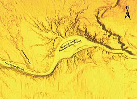
 The results of glacial drainage, both englacial (Arrow Hills Esker) and proglacial (Assiniboine Spillway) are clearly visible on the DEM. The esker is approximately 15 metres in height and composed of coarse shale gravel. The spillway is 70 metres deep and mostly erosional. The Assiniboine flats, an anomolous area of deposition within the spillway is an area which is very actively mined for sand and gravel.
Sand and Gravel Deposits Image #1
- Sand and Gravel Deposits Image #2
- Sand and Gravel Deposits Image #3
- Sand and Gravel Deposits Image #4
- Sand and Gravel Deposits Image #5
Undraped DEM, 8.0x VE, Orthogonal View
For a large view of this image


