Geoscience
Diamonds in Manitoba
Knee Lake Diamond OccurrenceThe first confirmed occurrence of diamonds in Manitoba is located at Knee Lake. The diamonds are hosted by Archean sedimentary rocks that may have been derived from coeval lamprophyric volcanism. This discovery resulted from the work of the Manitoba Geological Survey in partnership with Lynx Consortium, a group of prospectors and geologists.For additional information of the geology of this occurrence, please download Manitoba Geological Survey Open File OF2017-3: Preliminary geology of the diamond occurrence at southern Knee Lake, Oxford Lake–Knee Lake greenstone belt, Manitoba (NTS 53L15).
Kimberlite-indicator MineralsSampling of surficial sediments in parts of Manitoba has revealed a wide range of kimberlite-indicator mineral (KIM) suites, with promising results in the Hudson Bay Lowlands, southwest Manitoba, the northern Superior province, and at Southern Indian Lake in the Trans-Hudson orogen. Among the indicator minerals are garnets of G10 composition (low Ca, high Cr; potentially derived from diamond-forming regions in the mantle), which were recovered in samples from the northern Superior province and from areas underlain by Mesozoic bedrock in southwest Manitoba. KIM sampling programs are ongoing in several parts of the province to expand and improve the data coverage.
Manitoba Kimberlite-indicator Mineral Database (Version 3.2)by G.R. KellerReleased date: May 6, 2019 Note: Zip file re-released on October 21, 2019 with text edits to reference format and contact information within "ReadMe" document. Zipped Microsoft® Access 2016 database, 2.5 MB Supersedes OF2003-3, OF2004-1, OF2004-2 and OF2004-25 |
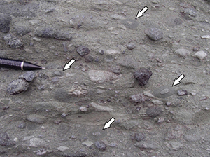
Outcrop photograph of pelletal lapilli (arrows) from the diamondiferous polymictic conglomerate, Knee Lake (click image to enlarge).
Kimberlite-indicator mineral data in Manitoba (click image to enlarge). |
|
This searchable database contains a compilation of results from all available, non-confidential, kimberlite-indicator mineral surveys completed in Manitoba. The database houses sample location, sample preparation and reference data as well as microprobe analyses of heavy mineral grains. The database can be searched by geographic area and/or mineral or chemical attributes using basic database search techniques. Download version 3.2 Information on previous database versions: Version 3.1.1 This database included data from De Beers Canada Exploration Inc. as well as data from Indicator Explorations Ltd., Kennecott Canada Explorations Inc. and the Erik Nielsen 2002 Hudson Bay Lowland survey. Version 3.1.1 was a data ‘fix’ version, resolving a data issue found with OF2002-1 and GP2002-1. Version 3.0 The database included data from De Beers Canada Exploration Inc. as well as data from Indicator Explorations Ltd., Kennecott Canada Explorations Inc. and the Erik Nielsen 2002 Hudson Bay Lowland survey. Version 3.0 featured a customised query form providing additional query options to facilitate searching as well as the ability to create and view Shapefiles from queried data.
Manitoba's Integrated Anomaly MapCompilation of structural, topographic, potential field and geologic data focussed toward identifying deep crustal structures and occurrences of kimberlite. More details |
||


