Geoscience

Pas Moraine
Introduction:
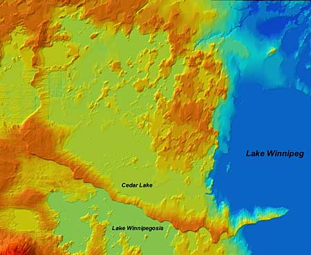
 The Pas Moraine is the most prominent glacial feature in south central Manitoba. It is more than 300 km long from Clearwater Lake in the north to Long Point in the east. The moraine is a thick wedge of till up to 20 km wide that rises as much as 60 m above the surrounding terrain. The proximal, northeastward facing slope of the moraine is a gentle ramp (~3 m/k) with streamlined features perpendicular to the moraine trend curving to merge with the lobe-shaped crest, while the distal slope is relatively steep (>20 m/k).
The process that led to the construction of the Pas moraine may have been similar to the model put forth for ice streams, past and present, in Antarctica. Seismic studies on the Antarctic ice stream B show that the glacier is riding on a 6 m layer of saturated glacial debris. It was concluded that most of this deformation till is derived from an up ice source and not derived locally. The deformation till is continuously being carried toward the ice margin and if the ice marginal position was maintained in the vicinity of the Pas Moraine for some time, deformation till would accumulate at the ice margin and eventually avalanche down the distal slope. This process would have generated a stratigraphic record similar to that of a delta, but composed of unsorted debris: what could be referred to as a till delta.
This process may also explain the formation of the curvilinear streamlined landforms up ice from the Pas Moraine and to the south. In a proglacial lake environment, where the majority of the ablation is a result of iceberg calving, the subglacial morphology of the deformation till may have been left undisturbed.
Pas Moraine Image #1
(notice lobe shaped crest of moraine and transverse streamlined ridges)
Undraped DEM, 1.0x VE, Orthogonal View
For a large view of this image.


