
Lake St. Martin Emergency Outlet Channel (LSMEOC)
Background
The Lake St. Martin area is susceptible to flooding due to the low-lying land surrounding the lake, the limited outflow capacity on the Dauphin River, and artificially high inflows from Lake Manitoba through the Fairford River Water Control Structure. Wet conditions in 2010 resulted in lake levels reaching the maximum desirable level of 244.1 metres (801 feet) in January 2011, rising past flood stage of 244.4 metres (801.7 feet) in March 2011. Lake St. Martin water levels were further increased by record high spring flows on the Fairford River, resulting in a maximum water level of 245.5 metres (805.6 feet) in August. This was approximately 0.6 metres (2 feet) higher than the previous recorded maximum level. Shorelines and backshore areas around the lake were flooded and the high water levels forced the evacuation of community residents.
Construction and 2011 Operation
In the summer of 2011, while levels on Lake Manitoba and Lake St. Martin remained at or near the highest recorded levels, the Government of Manitoba commissioned and engineering study to explore options to lower water levels on the two lakes on an emergency basis. In addition to the already high water levels, an additional concern was that the Dauphin River has a tendency to form frazil ice, which can result in hanging ice dams; this can obstruct the channel and further reduce outflow. Modelling work performed by the consultants showed that under average weather conditions, if ice jams were to form and constrict outflow on the Dauphin River, the levels on Lake St. Martin could have risen as high as 246.583 m (809 feet). In addition, if Lake Manitoba outflows through the Fairford River Water Control Structure were reduced to ease the flooding on Lake St. Martin and reduce the chances of frazil ice formation, as was normally done during the winter until a solid ice cover forms on the Dauphin River, the water levels on Lake Manitoba would remain higher for a longer period of time. In their report, the engineering consultants modelled and assessed a number of different options and scenarios, including different outlets from Lake St. Martin, additional outlets from Lake Manitoba, and dams and diversions on the Assiniboine River. It was found that the most timely and cost-effective means to lower water levels on both Lake Manitoba and Lake St. Martin was to construct an emergency outlet from Lake St. Martin and to maximize the outflows through the Fairford River Water Control Structure over the winter.
The Lake St. Martin Emergency Outlet Channel (LSMEOC) was constructed in late summer and early fall and opened on November 1, 2011. The channel was immediately put into operation to increase outflow from Lake St. Martin. Design and construction of the LSMEOC was a hug project, undertaken in a remote area on short notice and on an emergency basis, during summer and fall when construction is more difficult in such a wet, marshy area. The channel has a capacity of 113 cubic metres per second (4,000 cubic feet per second) when the Lake St. Martin water level is at 244.75 metres (803 feet). (“Cubic metres per second” is abbreviated as “cms”. “Cubic feet per second” is abbreviated as “cfs”.) The LSMEOC was closed in late November 2012 by placing impermeable material across the channel opening in compliance with the emergency authorizations received from regulatory agencies.
2014 Operation
On June 25, 2014, Manitoba announced that the LSMEOC would be reopened in early July due to record rainfall and resultant high water levels on Lake St. Martin and Lake Manitoba. The decision to reopen the LSMEOC was made prior to the large rainfall event over western Manitoba in late June that caused significant overland flooding and pushed the Assiniboine River and many other streams into flood stage.
Manitoba re-opened the LSMEOC in early July, 2014, which significantly increased outflow from Lake St. Martin and helped to lower lake levels. Manitoba closed the LSMEOC in the latter part of August, 2015.Operation of the LSMEOC helped to lower Lake St. Martin levels from a peak of 803.6 feet to around 800 feet in October 2015.
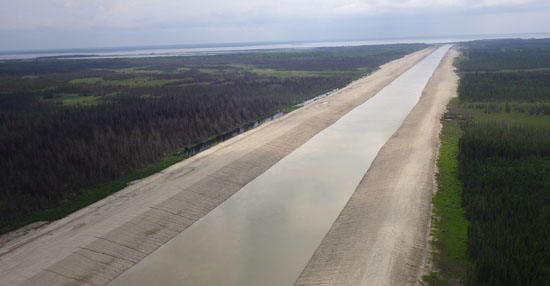
Aerial view of the Lake St. Martin Emergency Outlet Channel,
looking west towards the inlet at Lake St. Martin
The LSMEOC consists of three parts (reaches):
- Reach 1: 6.1 km (3.8 miles) long constructed channel, created to direct water from Lake St. Martin into Big Buffalo Lake
- Reach 2: consists of the Buffalo Creek, a natural waterway which flows from Big Buffalo Lake to enter the Dauphin River just upstream of Lake Winnipeg
- Reach 3: 6 km (3.7 miles) long constructed channel, which can be used to take water from Buffalo Creek and divert it directly to Lake Winnipeg to keep the water from entering the Dauphin River, reducing the chances of ice formation on the Dauphin River. Reach 3 has never been put into operation.
Operating Guidelines
The LSMEOC was constructed to function as an emergency structure, to reduce exceptionally high water levels on Lake St. Martin. Consequently, operation of the LSMEOC has been permitted by federal and provincial regulators only under a state of emergency and for defined periods of time. While there are no formal operating guidelines as such, operation of the LSMEOC has been restricted to times when Lake St. Martin water levels rise or are forecasted to rise above 244.75 metres (803 feet). Further, the LSMEOC has been required to be closed when water levels recede to 244.15 metres (801 feet). Additional restrictions were also placed on the timing of opening and closing the LSMEOC in order to minimize interference with periods of fish spawning.
Operational Information
Links to real-time data (Water Survey of Canada real-time gauges)