
Lake Manitoba
Lake Manitoba is the third largest lake in Manitoba, the thirteenth largest lake in North America (Modern Sedimentology and Hydrology of Lake Manitoba, 1984) and the 33rd largest lake in the world. It covers a surface area of approximately 4,700 km2(1,810 square miles) and has approximately 915 km (569 miles) of shoreline (The Lake Manitoba Regulation Review Advisory Committee, 2003). The lake is approximately 225 km (140 miles) long from north to south and is naturally divided into north and south basins at Lake Manitoba Narrows, which is roughly the midpoint of the lake. The south basin is broad and shallow with a silty lake bottom and with gently sloping shorelines, which are primarily sand and clay. In contrast, the north basin shoreline is more irregular and exposed bedrock is prominent along the shore and on the lake bed (The Lake Manitoba Regulation Review Advisory Committee, 2003).
The Lake Manitoba watershed of approximately 79,000 km2 (30,500 miles2) covers a large portion of western Manitoba and extends into eastern Saskatchewan.
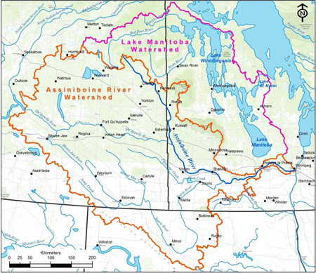
The Assiniboine River and Lake Manitoba basins
The majority of the watershed drains first into Lake Winnipegosis, and then into the Waterhen River, the largest source of inflow into Lake Manitoba. The only other significant tributary of Lake Manitoba is the Whitemud River, which drains the lands east and southeast of Riding Mountain and flows into the southwest corner of Lake Manitoba.
The sole point of outflow from Lake Manitoba is the Fairford River. From the lake, flows on the Fairford River reach Lake Pineimuta, then Lake St. Martin. The Fairford River Water Control Structure has served to regulate the water levels on Lake Manitoba since 1961, narrowing the range of high and low water events.
Read more about the Lake Manitoba and Lake St. Martin outlet channels here.