Williston Basin Architecture and Hydrocarbon
Potential (Phase 1)
TGI II Project
Mission:
To develop a seamless 3D
geological model of Paleozoic and Mesozoic-aged rocks, from
subsurface to outcrop, in Saskatchewan and Manitoba, in a geographic
area that extends the IEA Weyburn Monitoring and Storage project
area east and northeast into Manitoba, and west and north into
central Saskatchewan, in order to enhance our knowledge of
subsurface mineral potential (e.g. brines and potash), and
hydrocarbon migration and entrapment. This model will incorporate
geophysical and hydrogeological data to enhance our understanding of
hydrocarbon migration paths and traps, within and beyond,
traditional geographic areas of hydrocarbon production.
Objectives:
The overall objective was to
produce a geological model of Phanerozoic rocks over a significant
portion of Saskatchewan and Manitoba to enhance our understanding of
the hydrocarbon and mineral potential. This was done through
subsurface geological mapping, geophysical mapping, hydrogeological
mapping and remotely sensed imagery analysis.
Specific Objectives include:
- Identify major geological
units within the project area and their equivalencies in
Saskatchewan and Manitoba.
- Develop a web-enabled
compilation of existing literature and current geoscience
knowledge for the project area.
- Produce regional isopach
and structure maps for all major geological units in the study
area and present them in an ArcView GIS format with attached
attribute data.
- Acquire, and incorporate
seismic, aeromagnetic, and gravity data into a seamless 3D
regional geological model of the subsurface to improve our
understanding of the Precambrian basement and possible tectonic
relationship with overlying Phanerozoic rocks.
- Produce regional
hydrogeological model for strata of Paleozoic and Mesozoic age
within the study area.
Execution Strategy:
- Co-ordinate and seek alignment and synergy with all Task groups through meetings that address the issues of communication, data
sharing, and human and financial resources.
- Establish integration processes to link up inter-related tasks and integrate the information
from these tasks into the final product.
- Establish effective
execution and efficient use of resources, through such project
management tools as a Control Document, Project Schedule, Financial
Management system and Data Management system.
Study Area:
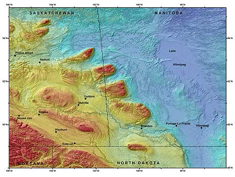
A geographic area that extends
the IEA Weyburn Monitoring and Storage project area east (to
approximately range 10E1) and northeast (to the Precambrian Shield
edge) into Manitoba, and west (to 30W2) and north (to Precambrian
Shield edge) in central Saskatchewan.
Scope, Responsibilities, Deliverables and
Budgets:
Legend:
GSC: Geological Survey of Canada; SMER: Saskatchewan Ministry of Energy and Resources; STEM: Manitoba Science, Technology, Energy and Mines (now Manitoba Economic Development, Investment, Trade and Natural Resources) and other partners.
Roles and Responsibilities*:
* The affiliations of the team members are shown as they were at the beginning of the project and do not necessarily reflect the current employer or employment status of the individual.
GSC Project Leader: Benoit
Beauchamp (GSC Calgary), Martin Fowler (GSC Calgary)
Steering Committee: Mike Cecile, Mark Williamson (GSC), Chris Gilboy (SMER), Ric Syme and John Fox (STEM): Steering committee members are responsible for the financial management and co-ordination of the project.
Provincial Project Leaders
(Co-leaders): Kim Kreis (SMER), Steve Whittaker (SMER), and Ruth
Bezys (Carol Martiniuk; STEM): Provincial Project leaders are
responsible for the management and co-ordination of efforts of the
various Tasks within their respective province and the co-ordination
and integration of work done in both provinces. Current Project
Leaders are Michelle Nicolas (STEM) and Melinda Yurkowski (SMER).
Principal Task Leaders: Kim Kreis (SMER), Steve Whittaker (SMER); Ruth Bezys, Carol Martiniuk
(STEM); Igor Morozov (University of Saskatchewan); Ben Rostron
(University of Alberta): Principle Task Leaders are responsible for
the co-ordination of program activities within the Task ensuring
that objectives are being met, deliverables are being provided and
timely reports are being issued. Communicate to the Project Leaders
problems and concerns of the Task members and request assistance.
Speak on behalf of Task members in their absence. Assist in
co-ordinating activities and flow of information with other
Principal Task Leaders and Researchers.
Task Members (Researchers): Develop appropriate technical plans (scope of work) to accomplish
the objectives and the deliverables committed to in the scope of
work. Carry out the work and be responsible for meeting cost,
schedule, scope and quality targets. Report on progress according to
a frequency and format conveyed by the Principal Task Leader.
| GSC |
SMER |
STEM |
Other Partners |
Mark Williamson
(GSC Atlantic) |
Chris Gilboy |
Ric Syme |
Ben Rostron
(U of A) |
Benoit Beauchamp
(GSC Calgary) |
Kim Kreis |
John Fox |
Dan Palombi
(U of A M.Sc. student) |
Martin Fowler
(GSC Calgary) |
Steve Whittaker |
Ruth Bezys |
Igor Morozov
(U of S) |
Mark Obermajer
(GSC Calgary) |
Andre Costa |
Carol Martiniuk |
Jiakang Li
(U of S Post- Doctoral Fellow) |
Kirk Osadetz
(GSC Calgary) |
Melinda Yurkowski |
Michelle Nicolas |
|
Lavern Stasiuk
(GSC Calgary) |
Jeff Coolican |
Gaywood Matile |
|
Alexander McCracken
(GSC Calgary) |
Megan Opseth |
Paul Lenton |
|
David McNeil
(GSC Calgary) |
Arden Marsh |
Greg Keller |
|
Arthur Sweet
(GSC Calgary) |
Andrew Nimegeers |
Glenn Conley |
|
| |
Erik Nickel |
Jim Bamburak |
|
| |
Tyler Music |
Len Chackowsky |
|
| |
Jim Christopher (Consultant) |
Craig Steffano |
|
| |
Don Kent (Consultant) |
Lori Janower |
|
| |
Patty Thomas (Consultant) |
Bonnie Lenton |
|
| |
Stacey Spooner (Consultant) |
Dan Barchyn (Consultant) |
|
| |
|
Derek Bogdan (Consultant) |
|
Project Duration and Timelines:
Funding: April 1, 2003 to March 31, 2005
Deliverables: April 25, 2005 to December 31, 2013
Budget (over two years):
GSC funds: $720 000
Provincial funds: $48 500
Total budget: $768 500

Digital elevation model of the TGI study area. (click to
enlarge)

|