Geoscience
Geological Survey Activity TrackerThompson Nickel Belt and Superior Boundary Zone
|
 Project Information
Principal investigators:
Chris Couëslan
Partnered with:
--
Location:
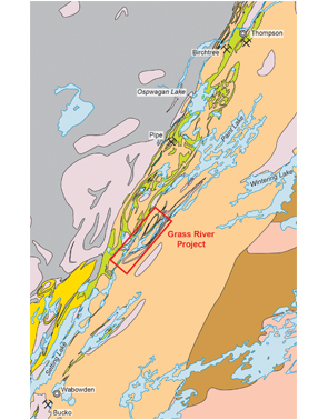
Grass River - Thompson Nickel Belt, parts of 63O1, 8 and 63P12
Project Description
Main objectives:
To trace the extent of Paint Lake group supracrustal rocks along the eastern margin of the Thompson Nickel Belt. Continue to gather information about the sequence and its petrogenesis and attempt to differentiate these rocks from highly metamorphosed Ospwagan Group rocks.
Methodology:
- 1:20 000 scale bedrock mapping of islands, shoreline, and ridgelines proximal to the Grass River;
- Isotopic, mineralogical, and geochemical characterization of various units.
Benefits:
Updated 1:20 000 geological maps will provide a better geological understanding of the eastern TNB. The project will hopefully improve the ability to discern Ospwagan Group rocks from the Paint Lake sequence. New exposures of Ospwagan Group stratigraphy towards the east could expand the area currently being explored for nickel in the TNB.
Completed outputs:
2016-2017
Couëslan, C.G. 2016: Geology of the Paint and Phillips lakes area, Thompson nickel belt, central Manitoba (parts of NTS 63O1, 8, 9, 63P5, 12); Manitoba Growth, Enterprise and Trade, Manitoba Geological Survey, Geoscientific Report GR2016-1, 44 p. and 1 colour map at 1:50 000 scale.
2012-2013
Couëslan, C.G. 2012: The Grass River Project: geological mapping at Phillips Lake, and new geochronological results from Paint Lake and Manasan Falls, Thompson Nickel Belt, central Manitoba (parts of NTS 63O1, 8, 9, 63P5, 12); in Report of Activities 2012, Manitoba Innovation, Energy and Mines, Manitoba Geological Survey, p. 68–78.


