![]() Geoscience
Geoscience
Geological Survey Activity TrackerSoutheast Manitoba
Detailed structural mapping and analysis of shear zones and auriferous vein systems in the Rice Lake mine trendProject Status: Completed (2019)
|
 Project Information
Principal investigators:
Scott Anderson
Partnered with:
Klondex Mines
Location:
NTS 52M4
Project Description
Main objectives:
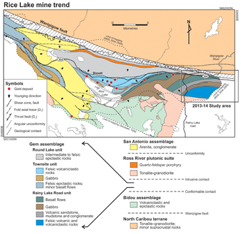
The objective of this project is to document the stratigraphic and structural settings and controls of gold mineralization in the Rice Lake area, and describe in detail the geometry, kinematics, and relative and absolute timing of shear zones and auriferous veins systems.
Methodology:
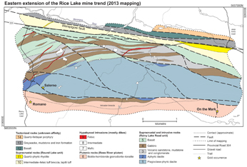
This project includes five main components: 1) detailed (1:100 scale, or greater) geological mapping and structural analysis of mineralized vein systems on surface and underground; 2) structural interpretation of LiDAR data from the Rice Lake mine trend, with emphasis on the hangingwall stratigraphy; 3) 1:5000 scale mapping and structural analysis of the Rice Lake mine trend, utilizing LiDAR-derived digital elevation models and orthorectified aerial photographs; 4) Re-Os geochronology to determine the absolute age of vein emplacement in the Rice Lake mine; 5) 1:10 000 scale mapping and structural analysis of the eastern extension of the Rice Lake mine trend (area burned in October 2011), utilizing LiDAR-derived digital elevation models and orthorectified aerial photographs.
Benefits:
 This project will build on the results of work completed under the auspices of the Rice Lake metallogeny project (MGS 2002-2013), and will provide key parameters for the formulation and testing of exploration models for vein-hosted gold mineralization in the Rice Lake greenstone belt.
Completed outputs:
2014-2015
Anderson, S.D. 2014: Orogenic gold deposits in the Rice Lake belt and the south margin of the North Caribou terrane; Manitoba Mineral Resources, Manitoba Geological Survey, Manitoba Mining and Minerals Convention 2014, Geology and Mineral Potential of Manitoba’s Premier Mineral Belts: Rice Lake/Bird River Belt Short Course, Winnipeg, Manitoba, November 19–21, 2014, oral presentation.
2013-2014
Anderson, S.D. 2013: Preliminary bedrock geology of the eastern extension of the Rice Lake mine trend, Rice Lake greenstone belt, southeastern Manitoba (parts of NTS 52M3, 4); in Report of Activities 2013, Manitoba Mineral Resources, Manitoba Geological Survey, p. 46–59.
Anderson, S.D. 2013: Geology and structure of the eastern extension of the Rice Lake mine trend, Rice Lake greenstone belt, southeastern Manitoba; Manitoba Mineral Resources, Manitoba Geological Survey, Preliminary Map PMAP2013-6, scale 1:10 000.
Anderson, S.D. 2013: Stratigraphy, structure and economic potential of the eastern extension of the Rice Lake mine trend, Rice Lake greenstone belt, southeastern Manitoba; Manitoba Mining and Minerals Convention, Winnipeg, Manitoba, November 20–22, 2013, oral presentation.
Anderson, S.D. 2013: The Rice Lake mine trend, Manitoba: regional setting, host rock stratigraphy and structural evolution of a classical Archean orogenic gold system; Geological Association of Canada–Mineralogical Association of Canada, Joint Annual Meeting, Winnipeg, Manitoba, May 22–24, 2013, Field Trip Guidebook FT-A1 and Manitoba Innovation, Energy and Mines, Manitoba Geological Survey, Open File OF2013-4, 47 p.
2011-2012
Anderson, S.D. 2011: Detailed geological mapping of the Rice Lake mine trend, southeastern Manitoba (part of NTS 52M4): stratigraphic setting of gold mineralization; in Report of Activities 2011, Manitoba Innovation, Energy and Mines, Manitoba Geological Survey, p. 94–110.
Anderson, S.D. 2011: Detailed geological mapping of the Rice Lake mine trend, southeastern Manitoba (part of NTS 52M4): structural geology of hostrocks and auriferous quartz-vein systems; in Report of Activities 2011, Manitoba Innovation, Energy and Mines, Manitoba Geological Survey, p. 111–126.
Anderson, S.D. 2011: Geology and structure of the Rice Lake mine trend, Rice Lake greenstone belt, southeastern Manitoba (part of NTS 52M4); Manitoba Innovation, Energy and Mines, Manitoba Geological Survey, Preliminary Map PMAP2011-3, scale 1:5000.
Anderson, S.D. 2011: Stratigraphic and structural controls on auriferous quartz vein systems in the Rice Lake mine trend, western Superior Province, Manitoba; Manitoba Innovation, Energy and Mines, Manitoba Geological Survey, Manitoba Mining and Minerals Convention 2011, Winnipeg, Manitoba, November 17–19, 2011, oral presentation.
Anderson, S.D. 2011: Stratigraphy and structural geology of the Rice Lake mine trend, Rice Lake greenstone belt, Manitoba; Manitoba Innovation, Energy and Mines, Manitoba Geological Survey, Manitoba Mining and Minerals Convention 2011, Winnipeg, Manitoba, November 17–19, 2011, poster presentation.


