![]() Geoscience
Geoscience
Geological Survey Activity TrackerNorthern Superior Province
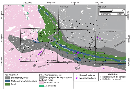
Surficial geology mapping and till composition of the western Fox River belt
|
 Project Information
Principal investigators:
Michelle Gauthier
Partnered with:
De Beers Group
Geomapping for Energy and Minerals – GeoNorth
Location:
NTS 53M15, 16 and parts of 53N13, 54C4, 54D1
Project Description
Main objectives:
To provide surficial geology maps, glacial history, and an understanding of till composition in the area.
Methodology:
- Surficial mapping with a helicopter, including collection of ice-flow indicators and till sampling (summers 2020, 2022).
Benefits:
A strong public geoscience knowledge base is recognized internationally as a key competitive advantage in profiling a jurisdiction’s geological potential and attracting investment in mineral exploration and development. The products from this project will provide direct input to ongoing mineral exploration initiatives in north-central Manitoba.
Plans for fiscal year 2024–2025:
- Release of year 2 KIM microprobe data
- Preparation of 1:50 000 scale surficial geology maps
- Preparation of ice-flow and till provenance release
Completed outputs:
2023-2024
Gauthier, M.S. and Hodder, T.J. 2023: Till geochemistry and heavy mineral analyses (gold, MMSIM®, visual KIM) of the western Fox River greenstone belt area, northeastern Manitoba (NTS 53M15, 16, parts of 53N13, 54C4, 54D1): year 2; Manitoba Economic Development, Investment, Trade and Natural Resources, Manitoba Geological Survey, Data Repository Item DRI2023015, Microsoft® Excel® file.
2022-2023
Gauthier, M.S. and Hodder, T.J. 2022: Field-based ice-flow indicator data from the Split Lake and Fox River belt areas, northeastern Manitoba (parts of NTS 53M15, 54D2, 54D4, 64A2); Manitoba Natural Resources and Northern Development, Manitoba Geological Survey, Data Repository Item DRI2022009, Microsoft® Excel® file.
Gauthier, M.S. and Hodder, T.J. 2022: Surficial geology mapping and till composition of the western Fox River greenstone belt area, northeastern Manitoba (NTS 53M15, 16 and parts of 53N13; 54C4; 54D1) – Year 2; in Report of Activities 2022, Manitoba Natural Resources and Northern Development, Manitoba Geological Survey, p. 96–109.
Hodder, T.J. and Gauthier, M.S. 2022: Kimberlite-indicator-mineral data derived from glacial sediments (till) in the western Fox River greenstone belt area, northeastern Manitoba (NTS 53M15, 16); Manitoba Natural Resources and Northern Development, Manitoba Geological Survey, Data Repository Item DRI2022010, Microsoft® Excel® file.
2021-2022
Gauthier, M.S. and Hodder, T.J. 2021: Till geochemistry and heavy mineral analyses of the western Fox River greenstone belt area, northeastern Manitoba (NTS 53M15, 16), plus 4 samples from the Gillam area (parts of 54D7, 11); Manitoba Agriculture and Resource Development, Manitoba Geological Survey, Data Repository Item DRI2021010, Microsoft® Excel® file.
Hodder, T.J. and Gauthier, M.S. 2021: Quaternary stratigraphic and depth to bedrock data compilation for northeastern Manitoba; in Report of Activities 2021, Manitoba Agriculture and Resource Development, Manitoba Geological Survey, p. 66–70.
Gauthier, M.S., Hodder, T.J., Lian, O.B., Finkelstein, S.A., Dalton, A.S. and Paulen, R.C. 2021: Stratigraphic, paleoenvironmental and geochronological investigations of intertill nonglacial deposits in northeastern Manitoba (parts of NTS 54B-F, K, L, 64A, H, I); in Report of Activities 2021, Manitoba Agriculture and Resource Development, Manitoba Geological Survey, p. 71–76.
2020-2021
Gauthier, M. S. and Hodder, T. J. 2020: Surficial geology mapping and till composition of the western Fox River greenstone belt area, northeastern Manitoba (NTS 53M15, 16); in Report of Activities 2020, Manitoba Natural Resources and Northern Development, Manitoba Geological Survey, p. 47-54.


