![]() Geoscience
Geoscience
Geological Survey Activity TrackerNorthern Superior Province
Geological compilation of the Oxford Lake–Knee Lake greenstone beltProject Status: Completed (2019)
|
 Project Information
Principal investigators:
Scott Anderson
Partnered with:
University of Manitoba (Prof. A. Chakhmouradian)
Location:
Parts of NTS 53L11, 12, 13, 14, 15; 53M1, 2; 63I9, 16
Project Description
Main objectives:
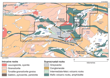
To produce an updated bedrock geology compilation for the Oxford Lake–Knee Lake greenstone belt, in order to better constrain the stratigraphy, tectonic evolution, metallogeny and exploration potential.
Methodology:
The Oxford Lake–Knee Lake belt was mapped by MGS at 1:31680 scale in 1971–1973 as part of the ‘Greenstone Project’, and the results of this work were released in 1985 as Geoscientific Reports GR83-1A and 1B. Subsequently, shoreline exposures on Knee Lake were re-mapped by MGS at 1:20000 scale in 1997–1998 under the auspices of the Western Superior NATMAP Project. New lithologic, geochemical, structural and geochronological data collected during this project provided important new insights into the stratigraphy, tectonic evolution and mineral potential of the belt and region, but were never formally published.
The present project aims to compile data from previous mapping, together with data from new MGS shoreline mapping at Oxford Lake (2012–2013) and Knee Lake (2015–2017), to produce a seamless series of bedrock geology maps for the entire Oxford Lake–Knee Lake belt. The project will employ a multidisciplinary approach that includes bedrock mapping of key areas on Knee Lake, in conjunction with structural analysis, lithogeochemistry, Nd-Sm isotopic studies, U-Pb geochronology (LA-MC-ICPMS and TIMS) and mineral deposit investigations. The project will also take advantage of industry high-resolution aeromagnetic survey data acquired in 2001, which covers the entirety of Knee Lake.
Benefits:
This project will build on the results of the Greenstone and Western Superior NATMAP projects and will provide valuable new geoscientific data to the mineral exploration industry and the Bunibonibee (Oxford House) Cree Nation.
Fieldwork in 2016 resulted in the discovery of calcite carbonatite dikes at central Knee Lake, indicating potential for rare metal mineralization, possibly associated with the Cinder Lake alkaline intrusive complex, as well as the discovery of diamondiferous conglomerate at southern Knee Lake, which will be evaluated in 2017.
Completed outputs:
2016-2017
Anderson, S.D. 2016: Preliminary results of bedrock mapping at central Knee Lake, northwestern Superior province, Manitoba (parts of NTS 53L15, 53M2); in Report of Activities 2016, Manitoba Growth, Enterprise and Trade, Manitoba Geological Survey, p. 1–15.
Anderson, S.D. 2016: Alkaline rocks at Oxford Lake and Knee Lake, northwestern Superior province, Manitoba (NTS 53L13, 14, 15): preliminary results of new bedrock mapping and lithogeochemistry; in Report of Activities 2016, Manitoba Growth, Enterprise and Trade, Manitoba Geological Survey, p. 16–27.
Anderson, S.D., Syme, E.C. and Corkery, M.T. 2016: Bedrock geology of south-central Knee Lake, Manitoba (parts of NTS 53L15, 53M2); Manitoba Growth, Enterprise and Trade, Manitoba Geological Survey, Preliminary Map PMAP2016-1, scale 1:15 000.
2015-2016
Anderson, S.D., Syme, E.C., Corkery, M.T., Bailes, A.H. and Lin, S. 2015: Preliminary results of bedrock mapping at southern Knee Lake, northwestern Superior province, Manitoba (parts of NTS 53L14, 15); in Report of Activities 2015, Manitoba Mineral Resources, Manitoba Geological Survey, p. 9–23.
Anderson, S.D., Syme, E.C., Corkery, M.T., Bailes, A.H. and Lin, S. 2015: Bedrock geology of the southern Knee Lake area, Manitoba (parts of NTS 53L14, 15); Manitoba Mineral Resources, Manitoba Geological Survey, Preliminary Map PMAP2015-1, scale 1:20 000.


