![]() Geoscience
Geoscience
Geological Survey Activity TrackerProvince-wide projects
3D Phanerozoic model of Manitoba |
Project Information
 Principal investigators:
Gaywood Matile (retired), Greg Keller
Partnered with:
None
Location:
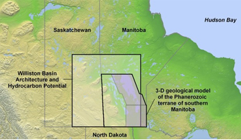
Southern Manitoba (south of 55° N), NTS 52E L M, NTS 53D E F K L, NTS 62F G H I J K N O P, NTS 63A B C F G H I J K
Project Description
Main objectives:
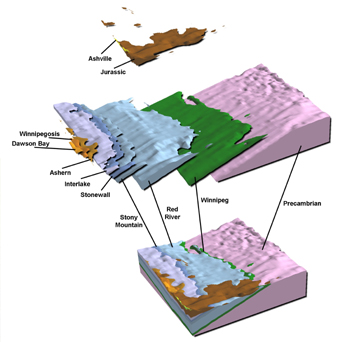
The main objective of this project is to construct a digital 3D model of the Phanerozoic stratigraphy of Manitoba south of 55° N utilizing several drill core databases. This model will also include a 3D representation of the underlying Precambrian surface.
Methodology:
- Synthesize data from a variety of sources (including digital elevation data, large lake bathymetry, surficial mapping, Lake Winnipeg seismic, drillhole databases, and the Stratigraphic Map Series).
- Generate five kilometre wide east/west transects comprising all of the resulting digital data.
- Interpret the transects into ‘vertical maps’ (interpreted cross-sections) and capture at a 5 kilometre east-west spacing generating a 5 kilometre grid of predicted stratigraphy points (PSP). Each PSP contains the tops of every stratigraphic unit at that location.
- Use 3D modeling software to transform the PSP tops into 3D surfaces, and then eventually solids representing Quaternary and Phanerozoic rock units.
 Benefits:
Portions of the Manitoba model have contributed to several projects and initiatives ranging from the Geological Survey of Canada's Prairie Province Hydrogeology initiative and Southern Prairie NATMAP to Manitoba Water Stewardship’s Water Branch utilizing the 3D model as a basis for groundwater modeling. It also provided support to the TGI project - Williston Basin Architecture and Hydrocarbon Potential.
Plans for fiscal year 2020–2021:
- No current plans, project is on hold
Completed outputs:
2013–2014
Keller, G.R., Matile, G.L.D., Thorleifson, L.H. 2013: 3D Geological Mapping in Manitoba – Moving Forward; Manitoba Mineral Resources, Manitoba Geological Survey.
Keller, G.R., 2013: 3D Geological Mapping in Manitoba – Moving Forward; Manitoba Mineral Resources, Manitoba Geological Survey, Three-Dimensional Geologic Mapping for Groundwater Applications, Denver, Colorado, GSA Annual Meeting, oral presentation.
2011–2012
Keller, G.R., Matile, G., Thorleifson, H. 2011: Manitoba Geological Survey: multi-scaled 3-D geological modeling with a single software solution and low costs; in Synopsis of current three-dimensional geological mapping and modeling in geological survey organizations, University of Illinois at Urbana-Champaign, Institute of Natural Resource Sustainability, Illinois State Geological Survey, Circular - Illinois State Geological Survey.
Matile, G.L.D., Keller, G.R. and Thorleifson, L.H. 2011: Three-dimensional geological mapping in Manitoba: overview and products; in Report of Activities 2011, Manitoba Innovation, Energy and Mines, Manitoba Geological Survey, p. 171–176.
Matile, G.L.D., Keller, G.R. 2012: Subsurface Phanerozoic geology of southern Manitoba; Manitoba Innovation, Energy and Mines, Manitoba Geological Survey, Stratigraphic Map MAP2012-1, scale 1:600 000.
2009–2010
Keller, G and Matile, G. 2009: Williston Basin 3D Geological Model; Manitoba Science, Technology, Energy and Mines, Manitoba Geological Survey, digital release only available at URL www. WillistonTGI.com [access date December 11, 2009]
Keller, G.R., Matile, G.L.D., 2009: The 3-D Geological Model of Manitoba, Canada, Central North America, Manitoba Science, Technology, Energy and Mines, Manitoba Geological Survey, Three-Dimensional Geologic Mapping for Groundwater Applications, Portland, Oregon, GSA Annual Meeting, oral presentation.
Nicolas, M.P.B., Matile, G.L.D., Keller, G.R. and Bamburak, J.D. 2010: Phanerozoic geology of southern Manitoba; Manitoba Innovation, Energy and Mines, Manitoba Geological Survey, Stratigraphic Map SM2010-1, 2 sheets, scale 1:600 000.
2005–2006
Morin, P. Matile, G.L.D. and Keller, G.R. 2005: 3-D topography of Manitoba; Manitoba Industry, Economic Development and Mines, Manitoba Geological Survey, Geoscientific Map 2005-3, 1 colour map. Scale 1:1 000 000.
2004–2005
Matile, G.L.D. and Keller, G.R. 2004: Shaded relief topography of Manitoba; Manitoba Industry, Economic Development and Mines, Manitoba Geological Survey, Geoscientific map 2004-4, 1 map. Scale 1:1 000 000
2003–2004
Keller, G.R. 2003: Slicing into Manitoba - Integrating Geography and Geology through Technology; Manitoba Industry, Trade and Mines, Manitoba Geological Survey, Manitoba Geological Survey; oral presentation at University of Winnipeg, January 15.
Matile, G.L.D. and Keller, G.R. 2003: 3D model installation and demo, Mirarco Virtual Reality Lab – Sudbury
Matile, G.L.D. and Keller, G.R., 2003: 3D model installation and demo, Industrial Technology Centre – Winnipeg
Matile, G.L.D., Keller, G.R., Thorleifson, L.H. and Pyne, D.M. 2003: Quaternary mapping progress in southern Manitoba Phanerozoic terrane: 2-D and 3-D; in Report of Activities 2003, Manitoba Industry, Trade and Mines, Manitoba Geological Survey, p. 231–238.
Ferguson, G., Woodbury, A.D., and Matile, G.L.D. 2003: Estimating Deep Recharge Rates Beneath an Interlobate Moraine Using Temperature Logs, Ground Water, v. 41, No. 5, pages 640–646
2002–2003
Burt, A.K, Brennand, Tracy A, Matile, Gaywood L.D., Keller, G.R., and Thorleifson, L.H. 2002: Reinterpretation of the Belair Moraine, Southeastern Manitoba, Canada, based on a regional digital elevation model and new geological data, North-Central Section (36th) and Southeastern Section (51st), GSA Joint Annual Meeting.
Matile, G.L.D., Keller, G.R., Thorleifson, L.H., and Pyne, M. 2002: 3-D Geological Model of southern Manitoba, Hydrogeology Workshop, Department of Engineering, University of Manitoba, Winnipeg, Oral presentation
Thorleifson, L.H., Matile, G.L.D., Keller, G.R. and Pyne, M. 2002: 3-D Geological Model of southern Manitoba, GSA Annual Meeting, Denver, Oral presentation
Keller, G.R., Matile, G.L.D, Thorleifson, L.H., and Pyne, M. 2002: 3-D Model of Manitoba; GIAC 2002-02 Workshop Series, Winnipeg, Oral presentation
2001–2002
Matile, G.L.D., Thorleifson, L.H., Bamburak, J.D., Bezys, R.K., Nicolas, M.P.B., Conley, G.G., Keller, G.R., and Pyne, M. 2001: Construction of a three-dimensional geological model for the southern Manitoba Phanerozoic Terrane; Manitoba Industry, Trade and Mines, Manitoba Geological Survey
Panagapko, D., Chackowsky, L.E., Lenton, P.G., Bailes, A.H., Corkery, M.T., Poulsen, K.H., Brommecker, R., Weber, W., Ames, D.E., Scoates, R.F.J., Garson, D.F., Theyer, P., Percival, J.A., Thorleifson, L.H., Matile, G.L.D., Grant, N.M., Burt, A.K., Mann, J.D. 2001: Geoscience data compilation for southeastern Manitoba; Manitoba Industry, Trade and Mines, Manitoba Geological Survey, Open File Report 2001-8
Thorleifson, L.H. Matile, G.L.D. Keller, G.R. Pyne, D.M. 2001: Development of protocols for 3D geological modeling in support of regional groundwater applications in the Winnipeg/Lake Winnipeg region, Canada; Geological Society of America, 2001 annual meeting, Boston, MA, Nov. 1-10, 2001, Abstracts with Programs, vol. 33, no. 6, p. 268.
1999–2000
Matile, G.L.D., Keller, G.R.,1999: Digital elevation model of southern Manitoba (version 1.0); Manitoba Industry, Trade and Mines, Manitoba Geological Survey, Open File Report, 99-15.


